History of the MacArthur Causeway

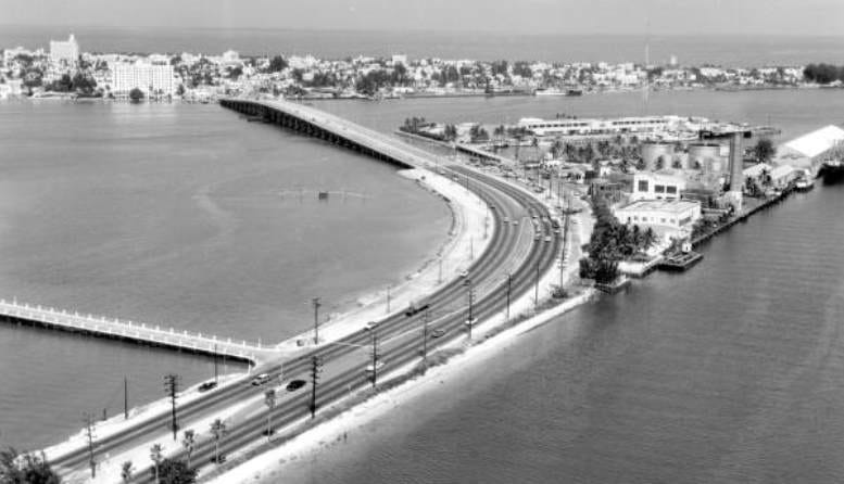
MacArthur Causeway in 1959Cover: MacArthur Causeway in 1959.

By the mid-1910s, some of the leaders of Miami and Miami Beach knew that the time would come when the region would outgrow the Collins Bridge, which was the only viaduct to join the two cities over Biscayne Bay. It was a privately-owned thoroughfare that charged each automobile a toll of 20 cents each direction to use the bridge. In order to accommodate the growth on both sides of the bay, these same leaders appealed to Dade County officials of the need for a second bridge.

It would take cooperation from several municipalities and a lot of patience to build the first publicly funded causeway. The county causeway, as it was originally referred, had its share of adversity, but it did finally open at the onset of a decade that would see both Miami and Miami Beach grow at an unprecedented rate. The bridge has changed names and has been updated several times during its 100-year history, but it still serves as a vital thoroughfare for a growing South Florida population.

Agreement to Build the Causeway

Headline in the Miami Metropolis on July 9, 1916

Figure 1: Headline in the Miami Metropolis on July 9, 1916.

When the Dade County Commission decided to fund and construct a new causeway over Biscayne Bay in 1915, they first needed to get the approval and a permit from the United States War Department. According to an article in the Miami Metropolis on August 30, 1915: “approval of the causeway plans must be had from the war department before any work can be done. A free channel through the causeway must be left, also sufficient openings all along so that water can flow back and forth between the upper and lower bay.” This approval may have been related to the covenants of the dredging and creation of Government Cut in 1905 which provided a shipping lane from the Atlantic Ocean to the municipal docks, which was located in today’s Museum Park. The federal government paid for the “cut” and therefore may have had a say in other projects effecting the shipping lane. The approval was granted on December 27, 1915.

The county also needed cooperation from the cities of Miami and Miami Beach to deed land for the entrance of the causeway on each respective side of the bay. Locke T. Highleyman, a Miami City Councilman at the time, was the lone dissenter in approving the plan for the causeway on behalf of the city of Miami. He felt that taxpayers shouldn’t be asked to fund such an elaborate project.

At the time, Highleyman was developing the Point View subdivision in Brickell and it was customary for the developer to pave and name the streets, as well as, provide the infrastructure for their project. Despite his initial concerns, he later aligned with the other city councilman and dropped his objection once an agreement was reached between the county and the city in October of 1916. Ironically, he would benefit from the causeway in the 1920s when he and his partner, Clarence Busch, created and developed Hibiscus and Palm Islands.

While the city and county negotiated an agreement, the county began a petition drive to gauge interest in a bond issue to raise enough money to construct the causeway. The drive indicated a strong interest in pursuing a bond issue and on July 18, 1916, County Chairman, S.A. Belcher presented the findings to the board of county commissioners. As reported in the Miami Metropolis in an article on July 9, 1916, Belcher requested that “a bond election be called at the earliest possible moment for the purpose of voting bonds in the sum of $600,000 for the purpose of erecting and constructing a causeway or highway consisting partly of rock fill and partly of bridge work between the city of Miami and the town of Miami Beach, according to plans approved by the war department of the United States government.”

Realizing that a second bridge to Miami Beach would benefit their business interests greatly, Carl Fisher and the Lummus brothers donated $2,000 to finance the costs associated with the special election. Just a few weeks after the board of commissioners gave their blessing, Dade county voters unanimously approved the bond issue by a two to one margin on August 23, 1916. The tax to repay the bond was figured to add $2.50 for every $3,000 in property value within Dade county.

Two months later, on October 16, 1916, the county and city of Miami came to an agreement to construct the causeway on public property. The county granted the city of Miami the right to build a steam railroad over the causeway at a later date. However, the county was granted the right to build a streetcar line over the causeway until the railroad tracks were constructed. While the county managed streetcar line operated from 1927 until 1939, the railroad was never built by the city.

Funding, Construction & Delays

Headline in Miami Metropolis on December 28, 1916

Figure 2: Headline in Miami Metropolis on December 28, 1916.

At the same time agreements were reached between all municipalities, the bond issue was validated by the courts and the county received its funding. However, there was a group of concerned citizens from the northern end of the county that filed a lawsuit stating that the entire county shouldn’t have to pay for a project that only benefited downtown Miami and Miami Beach. The injunctions that followed delayed the start of the project, but they were ultimately were settled.

The county awarded the dredging contract to the Bowers Southern Dredging Company. As soon as the contract was awarded, E.P. Maule filed a lawsuit claiming that his bid was the lowest and best bid, and that the county unfairly awarded the contract to Bowers. The suit necessitated a second injunction which served as another delay to the start of the project.

Once all lawsuits were resolved, work finally began for erection of the causeway on March 3, 1917. The county hired Klyce & Klackey to design the bridge and plot out the project timeline. The firm estimated the completion date of the causeway at October 1, 1918. The design and scope of the project were described in an article published in the Miami Metropolis on March 5, 1917:

“The causeway will be approximately three and one-half miles long. Two thousand feet on each end of the causeway was designed as viaduct construction while the central portion will be embankment, the bank being thrown up as a result of the excavation of the new ship channel being utilized for this purpose. The viaduct portion will be 40 feet wide and the causeway portion will be 105 feet wide.”

As it quickly as the project was started it was put on hold when the United States entered World War I on April 6, 1917. Infrastructure projects were halted to ensure that the country had enough raw materials and resources to fight a war overseas. A few months after the conclusion of the war on November 11, 1918, construction of the causeway resumed with a revised projected completion date of January 1, 1920.

County Causeway Opens in 1920

County Causeway in 1920

Figure 3: County Causeway in 1920.

As the end of 1919 got closer, it was apparent to county officials that the construction of the bridge was not close to being complete. In the first few days of January 1920, the commission lost confidence in Bowers to complete the project in a timely manner so they pulled the project and handed it over to county engineers to complete.

Despite the delays, officials in both Miami and Miami Beach assumed the causeway would open prior to the end of January. In anticipation of the opening of the bridge, land developers in Miami Beach placed ads in newspapers to promote their real estate interests near the entrance of the bridge onto the island side of the causeway. When the opening was delayed into February, finger pointing began, and county officials threatened to hand the project over to the two cities on each side of the causeway to let them finish and maintain it themselves. Ultimately cooler heads prevailed, and the county finished the project.

Despite all of the political wrangling, the causeway finally opened on February 17, 1920 at 2pm with very little fanfare. The delays in the opening of the bridge muted the excitement by the political leaders of all the affected municipalities. There was no ribbon cutting ceremony, and the opening was commemorated with several county leaders driving the first car from Miami to Miami Beach at the designated opening time. That first car featured J.C. Baile, member of the board of county commissioners; Hobart Crabtree, county engineer; and L.G. Norton, clerk to the board of county commissioners.

Built at a cost of $625,000, the causeway wasn’t quite complete when it opened on February 17th. Paving was only partially completed and there were several other details to be completed. Despite the work that still needed to be done, there were long lines of cars at both entrances waiting to cross the new bridge. Although there was no official count of the number of automobiles that crossed the bridge on its first day in service, from its opening at 2pm into the evening, there was a consistent and steady flow of cars in each direction.

Named General Douglas MacArthur Causeway in 1942

Coupon in Miami News on February 24, 1942

Figure 4: Coupon in Miami News on February 24, 1942.

By February of 1942, the United States was fully engaged in defeating the Axis powers after declaring war in response to the surprise attack on Pearl Harbor. General MacArthur was instrumental in overseeing the war in the pacific and was receiving accolades across the pond in Miami for his effort in defending the Philippines.

In an appeal in the Miami News on February 17, 1942, exactly twenty-two years to the day after the it opened, the paper’s editor suggested naming the county causeway in honor of the general. The headline read: “Let’s Honor A Great Soldier by Naming County Causeway MACARTHUR CAUSEWAY”. County causeway was considered more of a generic reference than a name, and the editor went on to write: “The causeway, one of the most heavily traveled transportation arteries in the world, has no official name… Naming it in honor of General MacArthur would not, of course, be anything more than a minor tribute to the great American fighter, but it would be a gesture, a fine gesture, on the part of the county toward paying homage to the man who bids fair toward becoming the outstanding American hero of the war.”

General MacArthur at American Legion Parade in 1951

Figure 5: General MacArthur at American Legion Parade in 1951.

The Miami News placed a coupon in the paper allowing the citizens of the county to provide their support for the idea. The Harvey Seeds post of the American Legion, whose membership included several men who fought under MacArthur in World War I, enthusiastically adopted a resolution urging the causeway be named for the general. Optimist clubs of the greater Miami area also endorsed the proposal.

Within two weeks of the suggestion by the Miami News, the county board of commissioners unanimously voted to designate the bridge as the General Douglas MacArthur causeway on March 3, 1942. In addition, the commission took action to erect plaques at both the east and west end of General MacArthur causeway to commemorate its naming.

It wasn’t until October of 1951 that the general was able to see the bridge that was named for him. General MacArthur was the guest of honor and featured speaker at the American Legion Convention hosted in Miami. The general presided over the American Legion parade from a reviewing stand and later gave a speech at Dinner Key Auditorium.

Replacement of Drawbridges in 1956 – 1960

MacArthur Causeway in 1959

Figure 6: MacArthur Causeway East End in 1959.

By the mid-1950s, the amount of traffic traveling on MacArthur Causeway necessitated a change in the configuration of the bridge. The original design included two draw bridges, one on each end of the causeway, which, when open, created an unmanageable bottleneck heading into or leaving Miami and Miami Beach. The county knew they needed to redesign the causeway on both sides to help alleviate the traffic issues plaguing the thoroughfare.

On January 13, 1956 the front-page headline in the Miami News announced a $316 million investment in infrastructure spending on a variety of construction projects around Dade County. One of the biggest projects was the replacement of the east drawbridge, located on the Miami Beach side of the causeway, with a fixed high bridge at an estimated cost of $5 million.

MacArthur Causeway in 1959

Figure 7: MacArthur Causeway West End in 1959.

The section replacing the low-level drawbridge was two thousand feet in length and thirty-five feet in height. The new section of the causeway was built to the north of the original draw bridge, which remained operational until its replacement was ready to open. The project began on July 19, 1956, and the new east section of the bridge opened on March 24, 1958.

Work to replace the drawbridge on the west end of the causeway, near Miami, began in late 1958 and was completed on February 22, 1961. Like the section of the bridge that was replaced on the east end of the causeway, the west end replacement was thirty-five feet in height to allow for boats to pass under the bridge rather than rely on a drawbridge to open and close.

Connecting Miami Project

Rendering of i395 Overpass

Figure 8: Rendering of i395 Overpass.

Once the section of Interstate I-395 connected I-95 with the MacArthur Causeway, the western entrance to the bridge allowed traffic to bypass downtown Miami and flow from interstate to causeway more freely. There is currently a multi-year project to replace that section of I-395 with a new cable-stayed bridge to replace the existing overpass. The $802 million project, known as ‘Connecting Miami’, will include a community park and art installations along a 1.4 mile stretch underneath the bridge. The project began in January of 2019 and is expected to be complete in late 2023.

Despite its rocky and delayed beginning, the MacArthur (formerly the ‘county’), Causeway has been one of South Florida’s most important thoroughfares. When there is a delay on the MacArthur it is felt up and down Miami-Dade County, regardless of the time of day. The configuration of the causeway has changed with the times and adapted to the demands that have been placed on it. Only time will tell how it evolves to address the challenges of the future that will most certainly include more traffic as the population of South Florida continues to grow.

Click Here to Subscribe


Resources

  • Book: “Miami Beach in 1920”, Abraham D. Lavender.
  • Miami News: “Causeway Honors Pacific Hero”, April 6, 1985 by Howard Kleinberg.
  • Miami News: “Quick Claim Deed Spoil Bank Land By Channel on Record”, December 27, 1915
  • Miami News: “Asking Election on Bond Issue for Causeway”, July 9, 1916.
  • Lakeland Evening Telegram: “Miami Votes $600,000 Bonds for Causeway”, August 24, 1916.
  • Miami News: “Agreement Reached By City and County on Causeway”, October 16, 1916.
  • Miami News: “Money Received for Building the Bay Causeway”, December 28, 1916.
  • Miami News: “Begin Work on Causeway Across Bay to Beaches Cost Will Be $600K”, March 5, 1917.
  • Miami Herald: “Traction Men to Meet Today”, April 3, 1919.
  • Miami Herald: “New Causeway is Formally Opened”, February 18, 1920.
  • Miami News: “Let’s Honor A Great Soldier”, February 17, 1942.
  • Miami News: “Causeway Officially Named for MacArthur”, March 3, 1942
  • Miami News: “Text of General MacArthur’s Speech Before The American Legion”, October 17, 1951.
  • Miami Herald: “56 Construction Due to Exceed Half-Billion”, January 13, 1956.
  • Miami Herald: “Work to Replace Causeway Draw Will Start Today”, July 19, 1956 by George Gilbody.
  • Miami News: “Span Will Be Safe, Beach Officials Say”, July 22, 1956 by Ken Heinrich.
  • Miami News: “Dade Getting 11 Million in Highway Jobs”, November 25, 1956.
  • Miami Herald: “Reporter Tries Out New MacArthur Bridge”, March 24, 1958.
  • Miami Herald: “MacArthur Causeway Bridge is Approved”, July 29, 1958.
  • Miami News: “New MacArthur Causeway Span Open for Business”, February 22, 1961.
  • Miami News: “Tributes to the General”, April 6, 1964.

Images

  • Cover: MacArthur Causeway in 1959. Courtesy of Florida State Archives.
  • Figure 1: Headline in the Miami Metropolis on July 9, 1916. Courtesy of the Miami News Archive.
  • Figure 2: Headline in Miami Metropolis on December 28, 1916. Courtesy of the Miami News Archive.
  • Figure 3: County Causeway in 1920. Courtesy of Florida State Archives.
  • Figure 4: Coupon in Miami News on February 24, 1942. Courtesy of the Miami News Archive.
  • Figure 5: General MacArthur at American Legion Parade in 1951. Courtesy of the Miami News Archive.
  • Figure 6: MacArthur Causeway East End in 1959. Courtesy of Florida State Archives.
  • Figure 7: MacArthur Causeway West End in 1959. Courtesy of Florida State Archives.
  • Figure 8: Rendering of i395 Overpass. Courtesy of State of Florida DOT.

2 Comments on "History of the MacArthur Causeway"

  1. Warren Grafer | February 25, 2020 at 9:27 am |

    Very interesting story, but I am surprised there is no mention of the trolley between Miami and Miami Beach that utilized the causeway. Not that I ever saw it personally, but I was told by a former neighbor years ago that his father had been a conductor on it. Was there indeed a trolley???

  2. Thanks for your comment, Warren. I wrote an article on Trolleys in Miami a while back. That article discussed the Miami to Miami Beach line. I will probably update the article with more content in the near future. The Trolley article can be found at: http://miami-history.com/history-of-the-trolley-in-miami. Thanks again for your feedback!

Comments are closed.