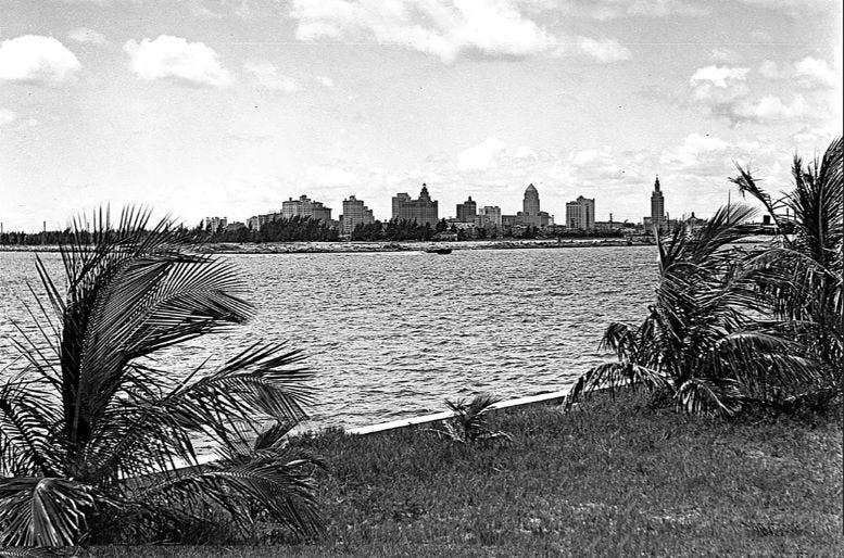
Watson Island – Isle of Grand Plans, Part 1 of 2
Part one of this two-part series will share the story of Watson Island, from its creation in 1931 through the end of the 1950s. The islet has been the focus of many big ideas for projects over time.

Most of the islands found in Biscayne Bay between the Rickenbacker and Julia Tuttle Causeways are man-made and were created between the early 1910s through the 1960s. The creation and use of each of these islands required the approval of, and in many cases, a monetary investment to the Florida Internal Improvement Trust Fund (IIF). This state-run fund controlled the rights of the waterways throughout the state of Florida and any land mass that is formed in any of those bodies of water. Decisions pertaining to the ownership and creation of man-made islands were made by the board of directors of this fund.
Many of the islands that were created in the 1910s and 1920s were established with development in mind. The project teams behind the creation of Palm, Hibiscus, Star, and the Venetian Islands all proactively sought approval from the state prior to initiating their projects. Burlingame Island, which later became Brickell Key on Claughton Island, began as a Spoil island which was put up for auction by the state trust fund and was awarded to Margaret Burlingame in 1912.
Watson Island, which was created as part of a deepening of the turning basin and ship channel for the Port of Miami, was another islet that fell under the purview of the state government. It was the IIF board of trustees who granted the rights and restrictions outlined in the deed that was granted to the City of Miami in the early 1930s. Although the grant of the islet by the state to the city was very specific in its purpose as “public use only”, the land mass has always been the focus of city officials who had big ideas on ways to monetize what many had referred to as the last “unexploited piece of property” within the city limits.
Causeway Bend Island Created in 1931

The island known today as Watson Island was originally referred to as ‘Causeway Bend Island’ after it was fully formed in 1931. While much of the spoil and fill was a by-product of the deepening of the turning basin for the Port of Miami, the initial formation of the islet began in 1928 with a dredging project to create a slip on the west side of the causeway. To create the original spoil isle, a temporary pipe line was laid across the causeway to facilitate the pumping of material from a dredge to what became the start of Watson Island.
Further development of the island continued in 1930 with a project to deepen the turning-basin and ship channel leading from the ocean to the Port of Miami, which was located at today’s Maurice Ferre Park in downtown Miami during the creation of the isle. Once completed, the island would consist of two sections of land mass on each side of the County Causeway, a thoroughfare that would be renamed to the MacArthur Causeway in 1942 to honor General Douglas MacArthur. The combination of the east and west parcels of land that enclosed the west bend of the causeway originally totaled 65-acres.
Shortly after the formation of the land mass, the Florida Internal Improvement Trust Fund board of trustees agreed to deed the island to the City of Miami under the condition that it be for public use only. Many residents of Miami believed that it would be best utilized as a public park, but city officials had different ideas.
Pan American Exposition Center

Even prior to the completion of the island, there were many in the city and county government that were pushing for the creation of a permanent Pan American Exposition Center within the city limits of Miami. While the proponents of this idea had a concept in mind, they did not have a place to host the center, but had begun making plans to pitch the idea using this newly created land mass for the project.
Despite the exposition initiative being inconsistent with the ‘public use only’ restriction, the Miami City Commission authorized $12,000 in February of 1931 to add an additional 15-acres of fill on the east parcel of the island to provide grounds for exhibits of products from Central and South American countries and for the annual Dade County Fair. The initiative had the full support of officials in both the city and county governments.
The city issued two certificates of indebtedness, due in one and two-year terms, to pay the Waldeck-Diehl Dredging Company, the company that held the government contract to do all of the fill work for the city at that time. While funding for the dredging work was authorized, the city needed to secure additional capital for the construction of the permanent exposition center and other buildings to support the project. They requested a $2 million loan from the federal government to complete the project.
However, after reviewing the proposal for the exposition design, federal officials rejected the city’s request for the loan because they believed “it was unlikely to produce earnings enough to retire such a loan.” The rejection was announced in February of 1934 and put the Pan American Exposition on hold for more than a decade. Given that the loan for the bulk of the project was rejected, the dredging for the additional 10-acres never happened.
The idea would be revisited more than a decade later in 1949 when the Miami mayor and city commission attempted to convince the IIF board of trustees to provide the city with the right to lease MacArthur Causeway land for private use. Their request was met with stiff opposition from the governor, and then led to an audit of existing leases on Causeway Bend Island to ensure they were consistent with the island’s deed restrictions.
Other Ideas for Island in 1930s

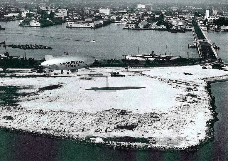
Despite the intent of the deed restriction confining the scope of the island strictly for public use, there was no shortage of ideas on how Causeway Bend Island could be monetized. Shortly after the state deeded the land mass to the city, in October of 1931, D.C. Coleman, the city manager, and A.H. Heermance, municipal aviation director, began negotiating a lease with the Goodyear Zeppelin Corporation for a dirigible (blimp) operation base. Goodyear was responsible for paying for the grading of the land for the base, and the city would receive ten percent of the revenue generated by Goodyear from blimp operations as rent.
In January of 1934, the city of Miami was approved for a grant for more than $158,000 to construct a sports stadium and city officials first considered the causeway island as the preferred location for the proposed 30,000 seat venue. The proposal required the city to raise an additional $212,000 to complete the project.
Ultimately, a grant and loan of $250,000 was approved by Harold L. Ickes of the Public Works Administration (PWA), which required that the proposed Municipal Stadium be constructed on land already owned by the city, and not acquired for the purpose of erecting the stadium, and the site must have been previously used for recreational activities. In January of 1936, the city realized that Causeway Bend Island would not meet the specifications for the grant and initially choose Moore Park as the proposed location of Municipal Stadium. After the assistant secretary of the PWA, Colonel Horatio B. Hackett attended the Orange Bowl game in January of 1936, the site of Municipal Stadium, along with the funding for the grant and loan, was shifted to the stadium that was eventually renamed to the Orange Bowl.
In June of 1935, Lieutenant Commander of the United States Navy, W.H. Green, worked with Miami City Commissioner Everest Sewell to propose a location for a $100,000 bay front site for a naval reserve armory. The city commission recommended Causeway Bend Island as a possible location for the facility. Ultimately, the idea never advanced beyond forming a committee to study the feasibility of funding and building the armory on the islet.
Miami Commissioner Alexander Orr Junior recommended putting a municipal pool and cabana colony on the north parcel of Causeway Bend Island in June of 1937. The proposed project had an estimated cost of $250,000 and the commissioner declared that the project would be “self-liquidating” based on entrance and cabana rental fees.
The proposed facility was described by a writer of the Miami Herald as follows:
“de luxe salt water bathing clean and safe, brought to Miamians in two pools amid a gay cabana colony setting.” There would be a deep pool with capacity for 800 swimmers designed along Olympic specifications, and a shallow pool with a capacity for 1,200 swimmers. Around the pools there would be a sand beach for up to 500 sun bathers. Along the outer edge of the beach would be two-story cabana buildings with a total of 500 units which could be rented by patrons of the facility.”
Ultimately, the project never got funded and did not materialize beyond the grand vision of one commissioner.


