The Miami River Upstream (1896 – 1915)

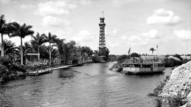
Lady Lou Sightseeing Boat and Cardale Tower in 1910Cover: Lady Lou Sightseeing boat and Cardale Tower in 1910.

It is hard to imagine a time when today’s NW 27th Avenue was once considered the edge of the Everglades. The original tributaries of the Miami River once included a very active north fork that included a majestic rapids which fed fresh water from the river of grass to the Magic City’s serpentine stream. Over the course of time, development in and around the tributary contributed to the disappearance of the natural flow of water from the rapids into the river.

Prior to decades of unfettered development, taking a trip down the Miami River provided a fascinating journey for visitors new to southeast Florida. Boat excursions down the watercourse would allow tourists to discover alligator wrestling, exotic fruits, and observation towers providing an unobstructed elevated view of a pristine yesteryear. There were several early tourist stops along the river that offered visitors the subtropical experience they traveled to Miami to find.

Richardson’s Grove

Charles O. Richardson at Musa Isle in 1905

Figure 1: Charles O. Richardson at Musa Isle in 1905

Otis Richardson was 76 years old and managing a citrus grove in Bronson, Florida when the freezes of 1894-95 changed everything. Like so many other farmers in northern Florida during this time, Richardson lost everything. Even at his advanced age, he and his wife felt the need to relocate to a part of Florida that was deemed frost proof by all accounts.

By the time the Florida East Coast (FEC) Railway finished extending the railroad to what would become the City of Miami in April of 1896, Otis Richardson and his wife had already purchased 15 acres of land on the south bank of the Miami River, just west of where the north fork of the stream began but to the east of today’s NW 27th Avenue. Their intent was to re-establish a citrus grove in an area described by early settlers as rich farm land.

Otis was joined by his son, Charles Otis (C.O.), and his wife a year later in 1897. The couple had been part of a traveling theatrical troupe for the prior twenty years and both were ready to get away from civilization when they decided to join his parents at their farm. They had traveled to every major big city during their acting junket and felt dropping out of the fast-pace big city lifestyle for a while would serve them well.

The Richardson family found guava and banana trees on their property when they arrived, but planned on growing grapefruit trees and other crops conducive to the area such as tomatoes, eggplant, and pineapple just to name a few. The vegetable crops provided a modicum of bridge income while the citrus and pineapple trees took time to bear fruit.

However, it was the guava trees that yielded the best opportunity for profit during the formative years of the farm. While a crate of guava only earned 75 cents, the trees on the farm were yielding 500 crates by the farm’s third season in 1899. The bountiful yield of guavas gave Charles the idea to begin making jelly, paste and marmalade out of the fruit.

Unfortunately, Otis died in 1901 prior to the farm realizing its full potential. Following his father’s death, Charles decided to rename the farm to the Musa Isle Fruit Farm. There was a story in the Miami News, published on August 13, 1933, which indicated that the name ‘Musa’ originally came from Charles wife’s maiden name. Her full name prior to marriage was Lillian Mussette Blake indicating that the original name of the farm was based on her middle name. However, as the story had been written, most visitors to the grove mispronounced Mussette as Musa, which led Charles to accept the abridged version for the farm name. He later thought that Musa being the botanical family name for banana offered a better story to how the farm name was conceived. Banana trees were prevalent at the entrance of the farm when Otis purchased the property in 1896.

The Isle was short for island given that the property was bordered by the north fork of the river on the northern boundary and everglades on all other sides, giving the impression that the property was on an island. In addition to changing the name, Charles also constructed a building to package and ship fruit for customers who purchased fruit or guava products but wanted them transported back home. As the City of Miami grew in the early 1900s, so did the interest of exploring the Miami River to experience everything the subtropics had to offer west of the Magic City.

Miami’s Fresh Water Pump Station

Map of Everglades Edge on Miami River in 1905

Figure 2: Map of Miami Pump Station, Everglades Edge, and Musa Isle on Miami River in roughly 1905

One of the challenges for the builders of early Miami was how they would provide fresh water to the residents of the developing city. The Flagler organization looked westward to build a pumping station which would draw fresh water from a spring near the rapids on the north fork of the Miami River, and transport it, via a pipeline, four miles east from the station to downtown Miami.

The pumping station was powered by gasoline which needed to be replenished on a frequent cadence. To account for the transport of fuel from the city to the pumping station, gasoline would travel by boat down the Miami River to the north fork at a landing located just east of today’s NW 29th Avenue, where it would be offloaded and travel by cart on a narrow-gauge railroad track the last couple hundred feet to complete the delivery. The Florida East Company was adept at constructing railway track, so it was only natural that the last leg of the journey would take place by rail, even though the cart had to be manually pushed from the landing to the pumping station.

This approach of extracting and pushing fresh water from the pumping station to the city only lasted one year. By 1898, a new pumping station was installed in the city which would extract and pull fresh water from the Everglade’s spring into the city. The rail tracks served its purpose for that one year and then were left abandoned after the new pumping approach was implemented.

Everglades Edge

In 1902, Reverend William H. Phipps purchased the land on the north bank of the north fork of the Miami River, between today’s NW 27th and NW 29th Avenue, up to the location of the original pumping station installed in 1896. He purchased the land with the intent of creating a farm and tourist attraction that he named ‘Everglades Edge’.

When he discovered the narrow-gauge train tracks on his property, he decided to extend the tracks around his entire property with the idea of providing tours of the exotic edge of the everglades. He made sure the tracks came close enough to the rapids to provide an additional scene on the sightseeing tour around his property. Furthermore, he constructed a two-story observation platform so his visitors can get a better view of the environs.

While there were paths and rudimentary roads that allowed visitors to drive to both Musa Isle and Everglades Edge, it wasn’t until there were regular boat excursions full of tourists that these destinations became popular. That would come one year after Phipps purchased his property.

Miami River Boat Excursions

Sallie Sightseeing Boat on Miami River

Figure 3: Sallie Sightseeing Boat on Miami River

In 1903, a man name E.L. Eaton setup the first boat excursions debarking from downtown Miami. His first excursion launch was the ‘Sallie’, which began taking tourists down the river to Alligator Joe’s near today’s Spring Garden Park, Musa Isle, and the Everglades Edge. Shortly after launching the Sallie, Eaton also added the Leo and Tiger Cat into his fleet of tour boats.

While Eaton started the river boat excursion business, he didn’t remain in it long. He sold the business and boats to Captain William L. Burch, who grew the fleet and added a second deck onto the tour boats to allow for the transport of more people.

The boat excursions were an instant hit with the tourists. It wasn’t long before there were multiple excursion boat operations that would travel in and around all destinations accessible by water. However, the Miami River excursions proved to be one of the most popular destinations. Tourists would meet at Avenue D and the River, or the Royal Palm Docks if they were staying at the hotel, and the tours would pick up and drop off passengers at least twice a day.

While the stops at Alligator Joe and Everglades Edge were exciting draws, the most popular stop was at Musa Isle Fruit Farm. Visitors were intrigued by the exotic fruits and guava products that they could purchase and send back to their home town. They could also purchase postcards to mail home to showcase the progress of the young city and its beautiful and exotic environs.

Musa Isle Sold in 1907

Article in Miami Metropolis on August 9, 1907

Figure 4: Article in Miami Metropolis on August 9, 1907

Business was good for Musa Isle Fruit Farm as the Richardson family prepared for the upcoming tourist season in 1906. However, two natural disasters changed everything for the business. Although best remembered for the impact it had on the construction of the Oversea Railroad, a major hurricane hit directly over Miami in October of 1906. It did extensive damage to Richardson’s grove, uprooting many trees, and damaged the facility where the guava products were made and packaged.

Charles replanted the lost trees and then constructed a new two-story jelly and marmalade plant to replace the original facility. However, the natural disaster was an omen for things to come the following year.

South Florida experienced an unprecedented drought beginning in the spring of 1907. The rapids completely dried up to the point were there wasn’t even a trickle of water being fed from the Everglades to the river which created a situation where water levels were dangerously low. The waterline was so low that fish were dying at such a prolific rate that the stench along the stream was bad enough for the Board of Health to issue an air quality warning for Miami residents.

This particular drought could not be blamed on man-made development. The Miami Canal, which was constructed beginning in 1910 and completed in August of 1912, was still in the planning stages in 1907. The Florida Internal Improvement Fund (IIF) was tasked with draining the Everglades to create more farmland in Florida. The creation of the Miami Canal was part of that effort which would facilitate future droughts, but could not be blamed for the one afflicting the Everglades and Miami River in 1907.

Given the challenges the hurricane and drought presented, Charles and his wife decided to sell the Musa Isle farm to J.C. Baile on August 9, 1907. Charles left farming but didn’t sit idle for long. On April 23, 1908, Richardson and a partner, W.F. Miller, purchased the Alcazar Theater in the Daniel’s building on Twelfth Street, or today’s East Flagler Street.

Daniels Building on Twelfth Street in 1910

Figure 5: Daniels Building on Twelfth Street in 1910. It is the gray building on the right with Iroquois Hotel on upper floor and Alcazar Theater on ground level

The partners were the first to introduce a rudimentary form of air conditioning for the theater. They raised the floor by two feet and placed blocks of ice under the floor and used electric fans to circulate the cool vapor from underneath the seating area. It was a short-lived experiment because most of the crowd complained of frozen feet and sweaty foreheads. Apparently, the cool air did not find its way above the audience’s ankles. Incidentally, the Daniels building still stands today at 41 East Flagler Street and was recently purchased by Moishe Mana in June of 2021.

Once Baile took over operations of the grove, he slowly began to add options to access Musa Isle Fruit Farm in order to increase foot traffic and ultimately revenue. By the fall of 1908, a circular rock road was constructed to allow for tour buses and motorists to encircle the glades and visit all the attractions without having to backtrack to return home. By the end of 1908, bridges over today’s NW 22nd and NW 27th Avenues provided access to vehicles arriving from across the river.

These changes provided options to visit by boat or vehicle. The tour buses, or rubberneck wagons as they were referred, could provide a tour of not only the river and its surroundings, but also all quarters of Miami including Southside, now known as Brickell, which was developing into an upscale residential millionaire’s row. Once accessibility to the western edge of the Miami River was attained and traffic increased, the one thing that was missing was an unobstructed and elevated view of the exotic environs of the Everglades.

Sallie Observation Tower in 1907

Sallie Observation Tower in 1908

Figure 6: Sallie Observation Tower in 1908

While the Everglades Edge farm provided a small platform to allow visitors to see further, it didn’t provide the type of panoramic view that got tourists excited. In January of 1907, the operator of the Sallie, Captain Burch, configured a landing (makeshift dock), and constructed a 60-foot observation tower near the bottom of the rapids on the north fork of the river. He called it the ‘Sallie Observation Tower.’

Burch cleared a path from the landing to the tower, which was located a short distance from the rivers edge, and placed wooden planks on the path as a makeshift walkway to get to the tower. Visitors would climb a three-story wooden staircase to ascend to the top of the observation deck. Once the visitor reached the observation platform, he or she would have a full 360-degree view of Miami and the Everglades as far as they can see.

A Miami Metropolis article on January 15, 1907, described the tower as follows:

“To the west a beautiful view of the Miami River and a partial view of the city can be had distinctly, all of which is very attractive and highly enjoyed by the visitors to the Everglades. The valley above the rapids is where the river is formed, all of which can be seen from the observatory.”

While the vista from the Sallie Observation Tower provided a unique view of South Florida for its time, every good innovation is normally replaced with something bigger and better over time. The Sallie was the talk of the town until the Cardale Resort constructed a larger and more impressive observation tower in 1910.

Cardale Resort in 1910

Postcard of Cardale Tower and Skating Rink

Figure 7: Postcard of Cardale Tower and Skating Rink

In 1909, Ira Milton Carr purchased property adjacent to the Musa Isle Fruit Farm which featured a clearing that looked very much like a valley. It was this clearing that perhaps influenced Milton to name his property the Cardale Grove. The ‘Car’ was based on his name and the ‘Dale’ was another word to describe a valley.

Like the proprietors of Musa Isle, Carr and his family had grander plans than just growing citrus trees on their property. On November 12, 1910, they announced the opening of a 135-foot observation stand that they called the Cardale Tower. A little more than a year later, on January 5, 1912, the family opened a skating rink next to the tower.

The Cardale Tower quickly eclipsed the Sallie Tower as the preferred destination for tourists and locals wanting to experience an aerial view of Miami and the Everglades. The skating rink became a venue for special events, celebrations, dances, and concerts. Milton Carr’s son, Kelly, was frequently mentioned in the Metropolis and Herald social pages as the host of his own boat excursion called the ‘Cardale’ where he would personally escort visitors around the resort.

On December 3, 1912, Milton agreed to sell the Cardale Resort to E.S. Frederick and Mrs. M.M. Eastham for $16,000 for the property and entire operation of the resort. Two weeks after the sale, the new owners announced that they had purchased a Ferris Wheel for $4,000 that would be located at the resort. The big wheel was said to be 150-feet in circumference, but the new owners did not disclose where it would be placed on the property.

The article in the Miami Metropolis (December 16, 1912) that announced the Ferris Wheel went on to tease the following:

“Several other plans are being laid for equally desirable attractions which will give Cardale additional claim to the premier amusement resort of the Magic City.”

Location of Sallie and Cardale Towers

Figure 8: Location of Sallie and Cardale Towers

Despite the claims made in the Metropolis article, the Ferris Wheel was never installed and there were no significant upgrades made to the Cardale Resort. Based on advertisements in the local newspapers, the attraction remained open through September of 1913, but was closed and the property was put up for sale by January of 1914.

The completion of the Miami Canal in April of 1913 changed the flow of water and enthusiasm for visiting the tourist outposts of the Cardale Resort, Musa Isle Fruit Farm and Everglades Edge. The Magic City and surrounding areas were growing and began to offer vacationers more than the river and Everglades as compelling tourist destinations. Those who wanted to explore the Everglades could travel further northwest along the Miami Canal after it opened.

Musa Isle After 1915

View from Cardale Tower Looking Westward

Figure 9: View from Cardale Tower looking westward in 1912. North Fork of Miami River to the left and Miami Canal to the right

As time marched on, the Musa Isle Fruit Farm transformed into the Musa Isle Indian Village. The Indian village remained in business at that location until 1964. The Cardale Resort and Everglades Edge properties were purchased and plotted for new subdivisions as demand for land in Southeast Florida exploded in the late 1910s and 1920s. Both the skating and rink and tower at the Cardale Resort were gone by the time Musa Isle Indian Village opened in 1919. It is mystery when both were completely removed, but one account by someone who grew up in the area and later went to work at the Indian village indicated that the tower had collapsed in the middle 1910s either due to fire or termite damage. While the base appears to have been constructed with hallow cinder blocks, the upper portion of the tower was constructed with wood.

As development marched westward, traces of these early tourist villages vanished. We have postcards and photographs to remind us of the primeval Miami River and Everglades of yesteryear, but nothing could replace the experience of taking the Sallie down the Miami River to disembark at the Cardale landing to climb a rickety wooden staircase to experience the beautiful panorama of a pristine river of grass of South Florida’s past. We cannot bring back that unspoiled vista, but we can close our eyes and imagine what that view would have offered.

Click Here to Subscribe


Resources:

  • Book: “The Miami River and Its Tributaries” by Donald C. Gaby
  • Tequesta Magazine: “The Early Years Upriver” by Donald C. Gaby (1988)
  • Miami Herald: “Service Thursday for Ira M. Carr” on January 18, 1956
  • Miami Metropolis: “Improvements on Upper Miami River” on January 15, 1907
  • Miami Metropolis: “Richardson Grove Has Changed Owners” on August 9, 1907
  • Miami Metropolis: “Opening at Cardale – Rink an Event Tonight” on January 5, 1912
  • Miami Metropolis: “Cardale Sold Today, $16,000 Consideration” on December 3, 1912
  • Miami Metropolis: “Ferris Wheel for Cardale Purchased Will Cost $4,000” on December 16, 1912
  • Miami Herald: “Abandon Theatrical Stage to Come South and Raise Fruits and Vegetables” on November 18, 1921.
  • Miami Herald: “E.L. Eaton Operated First Excursion Boats” on May 25, 1930.
  • Miami News: “Musa Isle Once Martin’s Island” on August 13, 1933.

Images:

  • Cover: Miami River at the split in the north fork and Miami Canal in 1910. The Lady Lou sightseeing boat is carrying tourist up the partially completed Miami Canal. Courtesy of Library of Congress.
  • Figure 1: Charles O. Richardson at Musa Isle in 1905. Courtesy of HistoryMiami Museum.
  • Figure 2: Map of Miami Pump Station, Everglades Edge, and Musa Isle on Miami River in roughly 1905. Courtesy of Don Gaby based on map originally created from A.L. Knowlton.
  • Figure 3: Sallie Sightseeing Boat on Miami River. Courtesy of Florida State Archives.
  • Figure 4: Article in Miami Metropolis on August 9, 1907. Courtesy of Miami News Collection.
  • Figure 5: Daniels Building on Twelfth Street in 1910. It is the gray building on the right with Iroquois Hotel on upper floor and Alcazar Theater on ground level. Courtesy of Alvin Lederer.
  • Figure 6: Sallie Observation Tower in 1908. Courtesy of Florida State Archives.
  • Figure 7: Postcard of Cardale Tower and Skating Rink. Courtesy of Larry Wiggins.
  • Figure 8: Location of Sallie and Cardale Towers. Courtesy of Don Gaby based on map originally created from A.L. Knowlton.
  • Figure 9: View from Cardale Tower looking westward in 1912. North Fork of Miami River to the left and Miami Canal to the right. Courtesy of Florida State Archives.